|

Quemahoning (Kwee-ma-hone-ing) A Delaware Indian name meaning "pine tree lick" Also the name of a creek in Quemahoning Township, Somerset County, Pennsylvania. © Quemahoning LLC 2018
|
| Quemahoning LLC Cultural Resource Management and Heritage Services |
Geomorphology
Geomorphology
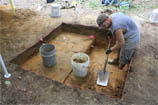
In certain circumstances, a geomorphological study is needed to determine the potential depth of archaeological deposits and to identify areas that have no potential for archaeological deposits due to prior ground disturbance. When a development project is located near streams or rivers, a geomoprhological study generates information need to design cost effective Phase I Archaeological Surveys. The geomorphologist or geoarchaeologist is a specialist who employs knowledge of soil formation and geological process that result in deeply buried archaeological sites within floodplains and other landforms where soils accumulate over time.
Landform Modeling
Quemahoning has developed a sophisticated GIS-base process for generating stream terrace models that reveal the spatial fabric of floodplains relative to the falling stream gradient. These stream terrace models help extrapolate information gained from soil auger probes across the stream terrace, and aid in designing appropriate Phase I testing methods.
Geoarchaeology
Geoarchaeology includes specialized studies of historic and prehistoric mine sites, mineral resource processing sites, and the cultural distribution of mined materials.
|
Featured
Projects
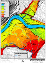
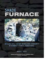
Hawthorn-Redbank-Redbank Municipal Authority Sewer Line Installation Project Quemahoning completed a geomorphological study of the proposed sewer line right-of-ways. The study identified areas of ground disturbance where archaeological testing was unnecessary and areas where deep archaeological testing was needed. Quemahoning worked closely with the project engineer to avoid areas requiring costly deep archaeological testing which resulted in significant project savings. U.S. Forest Service Salmon Creek Disperse Recreational Area Improvements Project Quemahoning completed a geomorphological study of Salmon Creek recreational areas within the Alleghney National Forest. The investigation identified archaeologically sensitive areas and delineated areas recommended for Phase I archaeological testing. Westfall Senior Appartments Project A geomorphological study was completed for a proposed development site along the Delaware River. The geomorphological study provided vital information regarding the need for deep archeaological testing which aided the site developer in redesigning the project to avoid costly archaeological surveys. Smith's Basin Prehistoric Chert Quarries Phase III Data Recovery Quemahoning developed methods of geoarchaeology to cost effectively analyze 4,300 lbs. of chert quarry debris from the Smith's Basin site. This analytical method offers an objective approach needed to make intra-site comparisons and comparisons between prehistoric quarry sites. Shade Furnace Ironworks, Somerset County, Pennsylvania Quemahoningn completed a geoarchaeology investigation of the iron ore mines and coal mines related to the Shade Furnace Ironworks. The geology of the Shade Furnace Ironworks was published in a book detailing the history of the ironworks. Shade Furnace: A 19th Century Ironmaking Community in Somerset County, Pennsylvania |