|
Archaeology 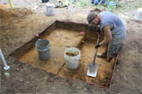
Quemahoning (Kwee-ma-hone-ing) A Delaware Indian name meaning "pine tree lick" Also the name of a creek in Quemahoning Township, Somerset County, Pennsylvania. © Quemahoning LLC 2018
|

| Quemahoning LLC Cultural Resource Management and Heritage Services |
Archaeology
Phase I: Site Identification - Phase I surveys are designed to determine if archaeological resources are present within your project area. The methods used to locate archaeological sites depend upon the type of ground and surface conditions within the project area. In agricultural areas, fields are plowed and disked, and the exposed soils are examined for the presence of artifacts. In areas where plowing is not possible, such as wooded areas or residential areas, archaeologists dig shovel test pits (STPs) at regular intervals (typically 50 ft) across the project area. Soil removed from STPs is screened to recover artifacts if present.
Phase II: Site Evaluation - Phase II surveys are designed to collect additional information on archaeological sites already discovered. The additional information is used to evaluate the importance of the archaeologcial site and to determine if the site is potentially eligible for listing on the National Register of Historic Places. The importance or research value of an archaeological site is judged against a set of standards established by the U.S Department of Interior National Register Program. Only those archaeological sites determined to contain significant research potential are designated as National Register eligible. Phase II surveys typically expand the area excavated during the Phase I survey to collect a larger sample of artifacts, and to look for evidence of subsurface refuse pits, fire hearths, foundations, and other structures created by the site's inhabitants.
Phase III: Mitigation of Adverse Effects - Archaeological mitigation seeks to preserve important information contained in National Register eligible sites that will be adversely affected by the development project. One form of mitigation is to redesign the development project so that ground disturbing activities will avoid the archaeological site. Avoidance is often the most logical and least expensive form of mitigation. If the development project cannot be redesigned then a Phase III Data Recovery Plan is negotiated and agreed to through a formal Memorandum of Agreement. The Data Recovery Plan is a research plan designed specifically for the archaeological site being mitigated. A typical Data Recovery Plan includes the excavation of a significant portion of the archeological site, and the analysis and interpretation of the artifacts and features discovered by the Phase III investigation.
The Pennsylvania State Historic Preservation Office (PA SHPO) is the state review agency for archaeological surveys conducted in Pennsylvania. Detailed descriptions of archaeological requirements and survey methods are provided in PA SHPO's 2016 guidelines:
Guidelines for Archaeological Investigations in Pennsylvania (1.6 MB - .pdf )
|
Featured
Projects
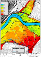
Hawthorn-Redbank-Redbank Municipal Authority Sewer Line Installation Project Phase I and Phase II Archaeological Surveys completed by Quemahoning gained cultural resources clearance for the construction of a sewerage treatment facility, two pumping stations, and 23 miles of collection pipelines. Quemahoning worked closely with the project engineer to avoid significant archaeological sites and averting costly Phase III mitigations. New Castle Natural Gas Pipeline Installation Project Phase I Archaeological Surveys completed by Quemahoning identified potentially significant archaeological sites and aided the project engineer in designing an avoidance plan that averted further Phase II archaeological surveys and project delays. U.S. Forest Service Clarion River Valley Disperse Camping Improvements Project Phase I and II Archaeological Surveys completed by Quemahoning provided archaeological clearance for construction of new campsite facilities along the scenic Clarion River within the Allegheny National Forest. The archaeological studies provided important information used by the Forest Service to develop interpretive displays that highlight the cultural heritage of the Clarion River Valley. Smith's Basin Prehistoric Chert Quarries, Phase III Data Recovery Quemahoning completed a Phase III excavation and analysis of the Smith's Basin Prehistoric Chert Quarry site in Washington County, New York. At the Smith's Basin site, prehistoric Native Americans mined chert or flint from pits dug into the ground and underlying bedrock. The investigation collected and interpreted important information about prehistoric mining methods and regional distributions of chert used for making stone tools. Completion of the data recovery plan facilitated Army Corp of Engineers clearance for a modern aggregate quarry mine permit. Borough of Enon Valley Caulfield Park Improvements Project A Phase I Archaeological Survey completed by Quemahoning gained archaeological clearance for improvements to the Caulfield Community Park and construction of a new baseball field. One archaeological site was identified. Further investigation and evaluation determined that the site was not National Register eligible. |